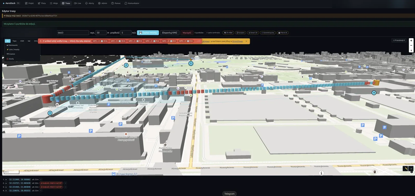
AeroDock prowadzi powtarzalne inspekcje linii przesyłowych, gazociągów, wodociągów, torów i ujęć wody dronami DJI Dock 3. Planowane przeloty dokumentują stan obiektu, a loty alarmowe reagują na awarie i wycieki — automatycznie, bez wysyłania ekipy w teren.
AeroDock runs repeatable inspections of transmission lines, pipelines, waterways, railways and water intakes with DJI Dock 3 drones. Scheduled flights document asset condition; alarm-driven flights respond to outages and leaks — automatically, without dispatching a field crew.
Linie przesyłowe, rurociągi i tory wymagają regularnej dokumentacji stanu, a awaria nie czeka na grafik. Ręczne obchody są wolne, kosztowne i niebezpieczne. AeroDock lata tę samą trasę co tydzień z dokładnością do centymetrów i porównuje wyniki misja po misji — a w razie alarmu jest na miejscu, zanim dotrze tam ekipa.
Transmission lines, pipelines and railways need regular condition records, and a failure won't wait for the schedule. Manual walk-throughs are slow, costly and unsafe. AeroDock flies the same route every week with centimetre repeatability and compares results mission over mission — and on an alarm it's on site before a crew can get there.
Powtarzalne misje wzdłuż linii, rurociągu czy torów według harmonogramu. Każdy przelot dokumentuje stan z tą samą trasą i parametrami — gotowy materiał do audytu i archiwum.
Repeatable missions along a line, pipeline or track on a schedule. Each flight documents condition with the same route and parameters — audit- and archive-ready material.
Sygnał o awarii, wycieku lub spadku ciśnienia uruchamia drona po trasie do miejsca zdarzenia. Dyspozytor ocenia sytuację z powietrza w kilka minut, zanim dotrze ekipa naprawcza.
A signal about an outage, leak or pressure drop launches the drone toward the incident. The dispatcher assesses the situation from the air within minutes, before the repair crew arrives.
Model 3D obiektu z fotogrametrii porównywany misja do misji. AeroDock automatycznie podświetla zmiany: ubytki, korozję, przemieszczenia, nową roślinność w pasie technicznym.
A photogrammetric 3D model compared mission over mission. AeroDock automatically highlights changes: defects, corrosion, displacement, new vegetation in the right-of-way.
Przed startem AeroDock sprawdza trasę lotu pod kątem kolizji z budynkami i liniami wysokiego napięcia na podstawie modelu 3D terenu. Lot wzdłuż infrastruktury bez ryzyka kontaktu.
Before take-off AeroDock checks the route for collisions with buildings and high-voltage lines using a 3D terrain model. Flight along infrastructure without contact risk.
Po każdym przelocie AeroDock składa ortofotomapę i modele terenu (DTM/DSM) na GPU. Dokładny, geometrycznie poprawny obraz pasa infrastruktury do pomiarów i porównań.
After each flight AeroDock builds an orthomosaic and terrain models (DTM/DSM) on the GPU. An accurate, geometrically correct image of the infrastructure corridor for measurement and comparison.
Każda misja kończy się raportem PDF z trasą, zdjęciami, znalezionymi zmianami i dziennikiem zdarzeń HMS. Gotowa dokumentacja dla operatora sieci i regulatora.
Every mission ends with a PDF report covering the route, imagery, detected changes and the HMS event log. Ready documentation for the network operator and regulator.
Pokażemy, jak AeroDock dokumentuje stan infrastruktury i reaguje na awarie na Twoim odcinku. Demo na żywo, bez zobowiązań.
We'll show how AeroDock documents asset condition and responds to outages on your section. A live demo, no strings attached.